| Spectacular Layers Exposed in Becquerel Crater
Toward the end of its Primary Mapping Mission, the Mars Global
Surveyor (MGS) Mars Orbiter Camera (MOC) acquired one of its most
spectacular pictures of layered sedimentary rock exposed within the
ancient crater Becquerel. Pictures such as this one from January 25,
2001, underscore the fact that you never know from one day to the
next what the next MOC images will uncover. While the Primary Mission
ends January 31, 2001, thousands of new pictures---revealing
as-yet-unseen terrain on the red planet---may be obtained during the
Extended Mission phase, scheduled to run through at least April 2002.
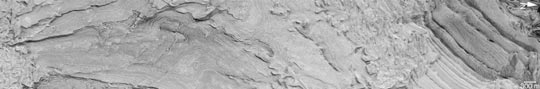
The picture shown here reveals hundreds of light-toned layers in
the 167 kilometers- (104 miles-) wide basin named for 19th Century
French physicist Antoine H. Becquerel (1852-1908). These layers are
interpreted to be sedimentary rocks deposited in the crater at some
time in the distant past. They have since been eroded and exposed,
revealing faults, dark layers between the bright layers, and a long
geologic history (of unknown duration) recorded in these materials.
Sets of parallel faults can be seen cutting across the layers in the left
third of the image. Sunlight illuminates this scene from the top/upper right.
Photo Credit: NASA/JPL/Malin Space Science Systems
|