|
Martian Dunes in Infrared
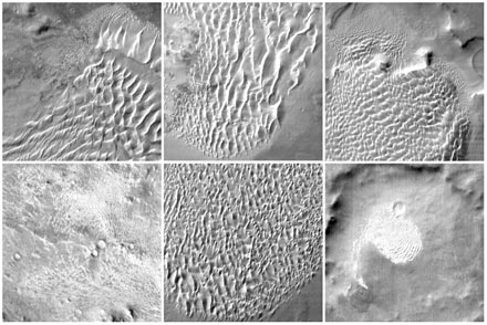
This collage of six images taken by the camera system on NASA's Mars
Odyssey, shows examples of the daytime temperature patterns of martian
dunes seen by the infrared camera. The dunes can be seen in this daytime
image because of the temperature differences between the sunlit (warm
and bright) and shadowed (cold and dark) slopes of the dunes. The
temperatures in each image vary, but typically range from approximately
-35 degrees Celsius (-31 degrees Fahrenheit) to -15 degrees Celsius (5
degrees Fahrenheit). Each image covers an area approximately 32 by 32
kilometers (20 by 20 miles) and was acquired using the infrared Band 9,
centered at 12.6 micrometers. Clockwise from the upper left, these images
are: (a) Russel crater, 54 degrees south latitude, 13 degrees east longitude;
(b) Kaiser crater. 45 degrees south latitude, 19 degrees east longitude;
(c) Rabe crater, 43 south latitude, 35 east longitude; (d) 22 north latitude,
66 degrees east longitude; (e) Proctor crater. 47 degrees south latitude,
30 degrees east longitude; (f) 61 degrees south latitude, 201 degrees
east longitude.
The Jet Propulsion Laboratory, a division of the California Institute of
Technology in Pasadena, manages the 2001 Mars Odyssey mission for
NASA's Office of Space Science in Washington, D.C. Investigators at Arizona
State University in Tempe, the University of Arizona in Tucson and NASA's
Johnson Space Center, Houston, operate the science instruments.
Additional science partners are located at the Russian Aviation and Space
Agency and at Los Alamos National Laboratories, New Mexico. Lockheed
Martin Astronautics, Denver, is the prime contractor for the project, and
developed and built the orbiter. Mission operations are conducted jointly
from Lockheed Martin and from JPL.
Image credit: NASA/JPL/Arizona State University.
|