JPL Home Page JPL Earth JPL Solar System JPL Stars and Galaxies JPL Science & Technology Jet Propulsion Laboratory California Institute of Technology Mars Reconnaissance Orbiter NASA Home Page Jet Propulsion Laboratory California Institute of Technology Follow this link to skip to the main content
NASA logo, Jet Propulsion Laboratory, California Institute of Technology header separator
+ NASA Homepage
+ NASA en Español
+ Marte en Español
GO!
Mars Reconnaissance Orbiter
Overview Science Technology The Mission People Features Events Multimedia
Mars for Kids
Mars for Students
Mars for Educators
Mars for Press
+ Mars Home
+ MRO Home
Multimedia
Summary
Images
bullet Press Release Images
bullet MOI
bullet Cruise
bullet Aerobraking
bullet Spacecraft
bullet Mars Artwork
bullet Dust Storms
bullet Launch
bullet Calibration
Videos
Press Release Images
Return to Press Release Images index
Bright Streaks and Dark Fans
Full Res JPG (1.30 MB)
11-Dec-2007
  Mars Orbiter Examines 'Lace' and 'Lizard Skin' Terrain
Full Press Release
Global View of Candor Chasm Study Location

Candor Chasma forms part of the large Martian canyon system named Valles Marineris. The location of Southwest Candor Chasma is indicated on this global map. The image is based on topographical information collected by the Mars Orbiter Laser Altimeter instrument on NASA's Mars Global Surveyor orbiter. Illumination is from the upper right. The image width is approximately 18,000 kilometers (11,185 miles).

Image credit: NASA/JPL-Caltech
Browse Image | Medium Image (89 kB) |
Full Resolution (3.2 MB)
Study Area within Southwest Candor Chasma

This view, covering an area approximately 580 kilometers (360 miles) wide, shows the location of a study area within Mars' Candor Chasma within regional context. The image is excerpted from a larger image (available at http://themis.asu.edu/zoom-20041008A) based on data collected by the Thermal Emission Imaging System camera on NASA's Mars Odyssey orbiter.

Rock layers in the indicated study area have been observed by the High Resolution Imaging Science Experiment camera on NASA's Mars Reconnaissance Orbiter.

Illumination is from the left, and north is up.

Image credit: NASA/JPL-Caltech/ASU
Browse Image | Medium Image (107 kB) |
Full Resolution (3.6 MB)
'Hilltop' View of the Terrain in Candor Chasma

This is a perspective view of a scene within Mars' Candor Chasma based on stereo imaging by the High Resolution Imaging Science Experiment (HiRISE) camera aboard NASA's Mars Reconnaissance Orbiter. It shows how the surface would appear to a person standing on top of one of the many hills in the region and facing southeast.

The hills in the foreground are several tens of meters to about 100 meters (tens of yards to about 100 yards) wide and several tens of meters or yards tall. The light-toned layers of rock likely consist of material laid down by the wind or under water. The dark-toned material is a layer of windblown sand on the surface. The orientations of these layers were measured in three dimensions in order to understand the region?s geologic history. The particular patterns in which these rocks are oriented to the surrounding Candor Chasma are most consistent with the idea that the layers formed as basin-filling sediment, analogous to the sedimentary rocks of the Paradox Basin in southeastern Utah. This implies that these sediments are younger than the formation of the chasm, providing important constraints on the maximum age of groundwater (about 3.7 billion years) within the region.

The width of the scene at bottom of the image is approximately 500 meters (1,640 feet). There is no vertical exaggeration.

The detailed three-dimensional information of the area comes from a pair of HiRISE observations. Those full observations are available online at http://hirise.lpl.arizona.edu/PSP_003474_1735 and http://hirise.lpl.arizona.edu/PSP_003540_1735.

Image credit: NASA/JPL-Caltech/Univ. of Arizona
Browse Image | Medium Image (116 kB) |
Full Resolution (1.8 MB)
'Low-flying' View of Terrain in Candor Chasma

This is a perspective view of a scene within Mars' Candor Chasma based on stereo imaging by the High Resolution Imaging Science Experiment (HiRISE) camera aboard NASA's Mars Reconnaissance Orbiter. It shows how the surface would appear from a few hundred meters or yards above the surface, as if from a low-flying airplane.

Layers of light-toned rock can be traced from the foreground up onto the hills in the background. Total vertical relief in this view is approximately 700 meters (2,200 feet). Regional views such as this help to tie together individual measurements of layer orientations and help to reveal regional patterns in the bedrock layering. These regional layer orientations provide insight into the geologic history recorded in the rocks. The dark-toned material is a surface layer of windblown sand. Width of the scene at the bottom of the image is approximately 1 kilometer (0.6 mile). There is no vertical exaggeration.

The detailed three-dimensional information of the area comes from a pair of HiRISE observations. Those full observations are available online at http://hirise.lpl.arizona.edu/PSP_003474_1735 and http://hirise.lpl.arizona.edu/PSP_003540_1735.

Image credit: NASA/JPL-Caltech/Univ. of Arizona
Browse Image | Medium Image (131 kB) |
Full Resolution (2.1 MB)
'Stair-Stepped' Terrain in Candor Chasma

This is a eastward-looking perspective view of a scene within Mars' Candor Chasma based on stereo imaging by the High Resolution Imaging Science Experiment (HiRISE) camera aboard NASA's Mars Reconnaissance Orbiter. It shows how the surface would look like from a viewpoint at few hundred meters or yards above the surface.

In the pictured area, layers of bedrock have been folded into a series of elliptical dome-like structures. The upper surfaces of these folds have been stripped away by erosion, leaving behind concentric patterns of layers and a ?stair-stepped? terrain morphology. The dark-toned material is a surficial layer of windblown sand that has been trapped against the ?steps? in the terrain. Patterns of layer deformation such as this record the geologic history of the region. The width of the scene at the bottom of the image is approximately 600 meters (about 2,000 feet). There is no vertical exaggeration.

The detailed three-dimensional information about the area comes from a pair of HiRISE observations. Those full observations are available online at http://hirise.lpl.arizona.edu/PSP_001918_1735 and http://hirise.lpl.arizona.edu/PSP_001984_1735.

Image credit: NASA/JPL-Caltech/Univ. of Arizona
Browse Image | Medium Image (109 kB) |
Full Resolution (1.7 MB)
Location of Sites Within 'Cryptic Terrain'

A regional landscape near Mars' south pole is called "cryptic terrain" because it once defied explanation, but new observations bolster and refine interpretations of how springtime outbursts of carbon-dioxide gas there sculpt intricate patterns and paint seasonal splotches. This map indicates locations of three sites that have been examined within the area of cryptic terrain, informally designated "Manhattan," "Giza" and "Ithaca." The underlying map offers context of brightness measurements from the Thermal Emission Spectrometer instrument draped over a shaded relief map based on data from the Mars Orbiter Laser Altimeter instrument. Cool colors are areas with a low albedo (dark) and warm colors are areas which have high albedo (bright). Both of those instruments flew on NASA's Mars Global Surveyor orbiter.

Image credit: NASA/JPL-Caltech/ASU
Browse Image | Medium Image (127 kB)
Global View of Mars Topography

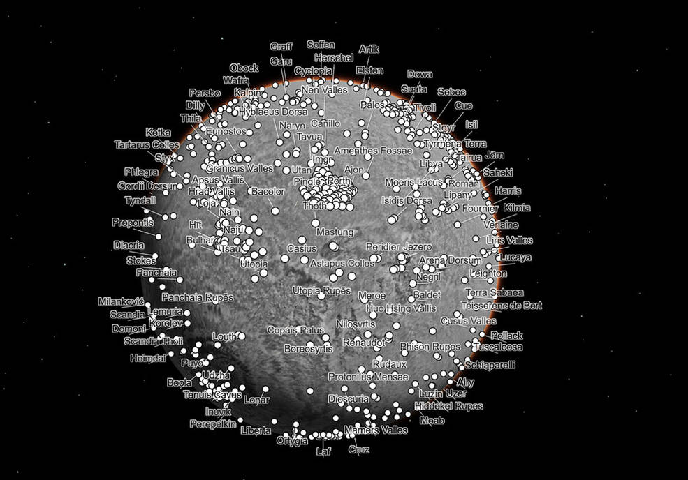
This global map of Mars is based on topographical information collected by the Mars Orbiter Laser Altimeter instrument on NASA's Mars Global Surveyor orbiter. Illumination is from the upper right. The image width is approximately 18,000 kilometers (11,185 miles).

Image credit: NASA/JPL-Caltech
Browse Image | Medium Image (101 kB) |
Full Resolution (3.2 MB)
Southwest Candor Chasma and Surroundings

This view, covering an area approximately 580 kilometers (360 miles) wide, includes the southwestern portion of Mars's Candor Chasma, part of the large canyon system named Valles Marineris.

The image is excerpted from a larger image (available at http://themis.asu.edu/zoom-20041008A) based on observations by the Thermal Emission Imaging System camera on NASA's Mars Odyssey orbiter.

Illumination is from the left, and north is up.

Image credit: NASA/JPL-Caltech/ASU
Browse Image | Medium Image (123 kB) |
Full Resolution (3.4 MB)
Field of Fans
Field of Fans

At the very beginning of spring in the southern hemisphere on Mars the ground is covered with a seasonal layer of carbon dioxide ice. In this image there are two lanes of undisturbed ice bordered by two lanes peppered with fans of dark dust.

When we zoom in to the subimage, the fans are seen to be pointed in the same direction, dust carried along by the prevailing wind. The fans seem to emanate from spider-like features.

The second subimage zooms in to full HiRISE resolution to reveal the nature of the "spiders." The arms are channels carved in the surface, blanketed by the seasonl carbon dioxide ice. The seasonal ice, warmed from below, evaporates and the gas is carried along the channels. Wherever a weak spot is found the gas vents to the top of the seasonal ice, carrying along dust from below.

The anaglyph of this spider shows that these channels are deep, deepening and widening as they converge. Spiders like this are often draped over the local topography and often channels get larger as they go uphill. This is consistent with a gas eroding the channels.

A different channel morphology is apparent in the lanes not showing fans. In these regions the channels are dense, more like lace, and are not radially organized. The third subimage shows an example of "lace."

Image credit: NASA/JPL-Caltech/University of Arizona
Browse Image | Medium Image (238 kB) | Large (618 kB)
Active Processes: Bright Streaks and Dark Fans

In a region of the south pole known informally as "Ithaca" numerous fans of dark frost form every spring. HiRISE collected a time lapse series of these images, starting at Ls = 185 and culminating at Ls = 294. "Ls" is the way we measure time on Mars: at Ls = 180 the sun passes the equator on its way south; at Ls = 270 it reaches its maximum subsolar latitude and summer begins.

In the earliest image fans are dark, but small narrow bright streaks can be detected. In the next image, acquired at Ls = 187, just 106 hours later, dramatic differences are apparent. The dark fans are larger and the bright fans are more pronounced and easily detectable. The third image in the sequence shows no bright fans at all.

We believe that the bright streaks are fine frost condensed from the gas exiting the vent. The conditions must be just right for the bright frost to condense.

Image credit: NASA/JPL-Caltech/University of Arizona
Browse Image | Medium Image (114 kB) | Large (810 kB)
 
New Vocabulary: Araneiform and Lace Terrains

The south polar terrain on Mars contains landforms unlike any that we see on Earth, so much that a new vocabulary is required to describe them. The word "araneiform" means "spider-like." There are radially organized channels on Mars that look spider-like, but we don't want to confuse anyone by talking about "spiders" when we really mean "channels," not "bugs."

The first subimage shows an example of "connected araneiform topography," terrain that is filled with spider-like channels whose arms branch and connect to each other. Gas flows through these channels until it encounters a vent, where is escapes out to the atmosphere, carrying dust along with it. The dark dust is blown around by the prevailing wind.

The second subimage shows a different region of the same image where the channels are not radially organized. In this region they form a dense tangled network of tortuous strands. We refer to this as "lace."

Image credit: NASA/JPL-Caltech/University of Arizona
Browse Image | Medium Image (120 kB) | Large (275 kB)
Color Reveals Translucent Seasonal Ice

In a region near the south pole of Mars translucent carbon dioxide ice covers the ground seasonally. For the first time we can "see" the translucent ice by the affect it has on the appearance of the surface below.

Dark fans of dust from the surface drape over the top of the seasonal ice. The surface would be the same color as the dust except that the seasonal ice affecting its appearance. Bright bluish streaks are frost that has re-crystallized from the atmosphere.

Sunlight can penetrate through the seasonal layer of translucent ice to warm the ground below. That causes the seasonal ice layer to sublime (evaporate) from the bottom rather than the top.

Image credit: NASA/JPL-Caltech/University of Arizona
Browse Image | Medium Image (74 kB) | Large (658 kB)
Science in Motion: Isolated Araneiform Topography

Have you ever found that to describe something you had to go to the dictionary and search for just the right word?

The south polar terrain is so full of unearthly features that we had to visit Mr. Webster to find a suitable term. "Araneiform" means "spider-like". These are channels that are carved in the surface by carbon dioxide gas. We do not have this process on Earth.

The channels are somewhat radially organized and widen and deepen as they converge. In the past we've just refered to them as "spiders." "Isolated araneiform topography" means that our features look like spiders that are not in contact with each other.

Image credit: NASA/JPL-Caltech/University of Arizona
Browse Image | Medium Image (71 kB) | Large (556 kB)
Bright Streaks and Dark Fans

The south polar region of Mars is covered every year by a layer of carbon dioxide ice. In a region called the "cryptic terrain," the ice is translucent and sunlight can penetrate through the ice to warm the surface below.

The ice layer sublimates (evaporates) from the bottom. The dark fans of dust seen in this image come from the surface below the layer of ice, carried to the top by gas venting from below. The translucent ice is "visible" by virtue of the effect it has on the tone of the surface below, which would otherwise have the same color and reflectivity as the fans.

Bright streaks in this image are fresh frost. The CRISM team has identified the composition of these streaks to be carbon dioxide.

Image credit: NASA/JPL-Caltech/University of Arizona
Browse Image | Medium Image (78 kB) | Large (630 kB)
 
Cryptic Terrain on Mars

There is an enigmatic region near the south pole of Mars known as the "cryptic" terrain. It stays cold in the spring, even as its albedo darkens and the sun rises in the sky.

This region is covered by a layer of translucent seasonal carbon dioxide ice that warms and evaporates from below. As carbon dioxide gas escapes from below the slab of seasonal ice it scours dust from the surface. The gas vents to the surface, where the dust is carried downwind by the prevailing wind.

The channels carved by the escaping gas are often radially organized and are known informally as "spiders."

Image credit: NASA/JPL-Caltech/University of Arizona
Browse Image | Medium Image (139 kB) | Large (289 kB)
Dry Ice Etches Terrain

Every year seasonal carbon dioxide ice, known to us as "dry ice," covers the poles of Mars. In the south polar region this ice is translucent, allowing sunlight to pass through and warm the surface below. The ice then sublimes (evaporates) from the bottom of the ice layer, and carves channels in the surface.

The channels take on many forms. In the subimage shown here the gas from the dry ice has etched wide shallow channels. This region is relatively flat, which may be the reason these channels have a different morphology than the "spiders" seen in more hummocky terrain.

Image credit: NASA/JPL-Caltech/University of Arizona
Browse Image | Medium Image (64 kB) | Large (445 kB)
Starburst Channels
Starburst Channels

Translucent carbon dioxide ice covers the polar regions of Mars seasonally. It is warmed and sublimates (evaporates) from below, and escaping gas carves a numerous channel morphologies.

In this example the channels form a "starburst" pattern, radiating out into feathery extensions. The center of the pattern is being buried with dust and new darker dust fans ring the outer edges. This may be an example of an expanding morphology, where new channels are formed as the older ones fill and are no longer efficiently channeling the subliming gas out.

Image credit: NASA/JPL-Caltech/University of Arizona
Browse Image | Medium Image (66 kB) | Large (455 kB)
Lizard-Skin Surface Texture

The south polar region of Mars is covered seasonally with translucent carbon dioxide ice. In the spring gas subliming (evaporating) from the underside of the seasonal layer of ice bursts through weak spots, carrying dust from below with it, to form numerous dust fans aligned in the direction of the prevailing wind.

The dust gets trapped in the shallow grooves on the surface, helping to define the small-scale structure of the surface. The surface texture is reminiscent of lizard skin.

Image credit: NASA/JPL-Caltech/University of Arizona
Browse Image | Medium Image (144 kB) | Large (947 kB)
Carbon-Dioxide Frost Settling from Seasonal Outbursts on Mars (Movie)

This movie, constructed by overlaying a time series of images taken by the Compact Reconnaissance Imaging Spectrometer for Mars (CRISM), shows seasonal changes and unearthly processes that occur in Mars' south polar seasonal frost cap. More >>

JPL Image Use Policy

Credits Feedback Related Links Sitemap
USA Gov
footer NASA logo