September 12, 2003
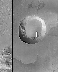 |
First MOC Public Requested Image: Caldera of Pavonis Mons
View larger images
NASA/JPL/Malin Space Science Systems
|
|
 |
|
Mars Global Surveyor (MGS) reached the red planet six years ago, on 12
September 1997 (UTC). The Mars Orbiter Camera (MOC) began acquiring
images a few days later, although systematic mapping from a nearly-circular,
nearly-polar orbit did not begin until March 1999. Now in its extended
mission, MOC continues to document and provide revelations about the
geology and meteorology of Mars with more than 130,000 images
received. The MGS MOC Public Target Request Site began taking public
and science community suggestions for areas on Mars to be imaged by
MOC on 20 August 2003. This pair of images is the first set to be
obtained through the Public Target Request effort. The picture on the
left is a MOC narrow angle (high resolution) view of a portion of the
lower wall and floor of the Pavonis Mons caldera. The image on the
right is a MOC red camera wide angle context image, taken at the
same time as the high resolution view. The white box in the context
frame shows the location of the high resolution picture.
The narrow angle MOC image has a resolution of 1.5 meters (~5 feet) per
pixel and covers an area 1.5 kilometers (~0.9 mile) wide by 9 kilometers
(5.6 miles) long. The context image covers much of the summit region of
Pavonis Mons; it is about 115 km (~72 mi) wide. Sunlight illuminates
both images from the lower left; north is toward the top/upper right;
east to the right. The high resolution view is located near 0.4°N, 112.8°W.
Pavonis Mons is a broad shield volcano; its summit region is
about 14 km (~8.7 mi) above the martian datum (above elevation 0); the
caldera is about 4.6 km (~2.8 mi) deep. The caldera formed by
collapse--a long time ago--as molten rock withdrew to greater depths
within the volcano. The new high resolution picture shows that today the
floor and walls of this caldera are covered by a thick (perhaps more than
1 meter/1 yard), textured mantle of dust. Larger boulders and rock
outcroppings poke out from within this dust mantle; they are seen as
small, dark dots and mounds on the lower slopes of the wall in the high
resolution image. The picture partially overlaps some of a previous,
lower-resolution view obtained in November 2001
(6 m/pixel; E10-01691 or subframe of E10-01691 in cases where a web browser cannot display an image with 16256 lines).
Each Public Target Request received at Malin Space Science Systems
(MSSS) is examined by MSSS personnel, then placed in a database where
it awaits a time in the future when the MGS spacecraft is predicted to fly
over the suggested target. Any given request might wait in this database
for weeks, months, or even a year or more; it is not possible to
know more than a few days in advance whether a specific target
is going to be imaged. The pair of images shown here were suggested
in late August, 2003. A predicted ground track was seen to
intersect the location of the requested picture on 1 September.
The image was acquired on 4 September and received on Earth the
following day. Data received through the MGS MOC Public Target Request
effort are posted once a month at: http://www.msss.com/mars_images/moc/publicresults/. The next posting is expected in late October 2003, if additional public images are acquired before then.
###
All Images Credit: NASA/JPL/Malin Space Science Systems
Malin Space Science Systems and the California Institute of Technology built the MOC using spare hardware from the Mars Observer mission. MSSS operates the camera from its facilities in San Diego, California. The Jet Propulsion Laboratory's Mars Surveyor Operations Project operates the Mars Global Surveyor spacecraft with its industrial partner, Lockheed Martin Astronautics, from facilities in Pasadena, California and Denver, Colorado.


