| Northern Terra Meridiani Rocks and Cliffs in 3-D
Extended Mission operations for the Mars Global Surveyor (MGS) Mars Orbiter Camera (MOC)
include opportunities that come up about 10 times a week to turn and point the MGS
spacecraft so that MOC can photograph a feature of high scientific interest. Many of these
images are targeted to the site of a previous MOC image, so that a stereoscopic ("3-D") view
can be obtained.
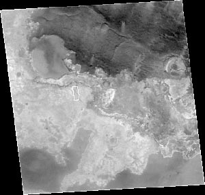
The top picture shows a 115 kilometers (~72 miles) wide portion of northern Terra
Meridiani, a region of vast layered rock outcrops similar to portions of southeastern Utah and
northern Arizona on Earth. The white box in this context image, located near 2.2°N, 1.3°W,
shows the location of the high resolution stereo view obtained by MOC by combining a
picture taken March 10, 1999 (FHA-00541) with one obtained by pointing the spacecraft on
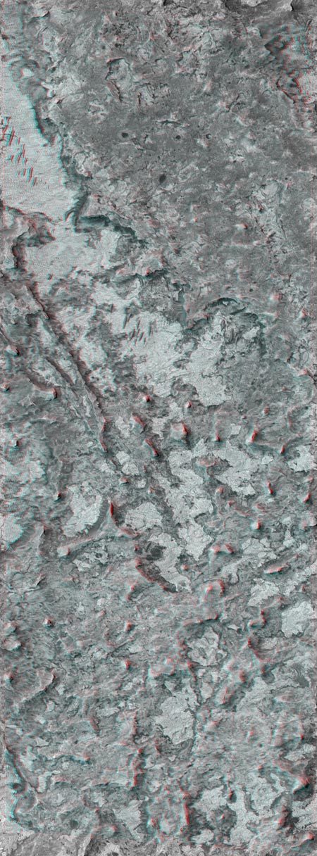
May 28, 2001 (EO4-02223). The stereo view, which requires red (left-eye) and blue
(right-eye) "3-D" glasses to be seen, covers an area approximately 2.3 km (1.4 mi) wide by
6.2 km (3.9 mi) long. The full-resolution view is seen at nearly 1.5 meters (5 ft) per pixel, a
scale at which objects the size of airplanes and school buses might be seen.
The landscape revealed by the 3-D view is a rugged terrain with steep cliffs and no fresh
impact craters. This terrain seems most un-Mars-like compared to the typical cratered and
dusty views MOC has provided since it began taking data in September 1997. In fact, one of
the MOC science team members remarked, "If I'd seen this landscape used in a movie about
Mars five years ago, I'd have said the director had no clue what Mars is supposed to look
like." An irregular depression with a flat, mottled, light-toned floor dominates the scene.
Small dark ridges on the depression floor near the top center of the image are dunes or
drifts formed by wind transport of sandy sediment. The sharp buttes, mesas, and steep cliffs
are all indicators that this terrain consists of a broad exposure of martian bedrock. North is
up and sunlight illuminates each picture from the left/upper left.
Images Credit: NASA/JPL/Malin Space Science Systems
|