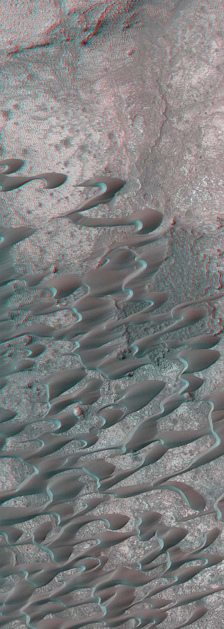
| Sand Dunes of Nili Patera in 3-D
The most exciting new aspect of the Mars Global Surveyor (MGS) Extended Mission
is the opportunity to turn the spacecraft and point the Mars Orbiter Camera (MOC)
at specific features of interest. Opportunities to point the spacecraft come about
ten times a week. Throughout the Primary Mission (March 1999 - January 2001),
nearly all MGS operations were conducted with the spacecraft pointing
"nadir"---that is, straight down. A search for the missing Mars Polar Lander in late
1999 and early 2000 demonstrated that pointing the spacecraft could allow
opportunities for MOC to see things that simply had not entered its field of view
during typical nadir-looking operations, and to target areas previously seen in a
nadir view so that stereo ("3-D") pictures could be derived.
One of the very first places photographed by the MOC at the start of the Mapping
Mission in March 1999 was a field of dunes located in Nili Patera, a volcanic
depression in central Syrtis Major. A portion of this dune field was shown in a
media release on March 11, 1999, "Sand Dunes of Nili Patera, Syrtis Major".
Subsequently, the image was archived with the NASA Planetary Data System, as
shown in the Malin Space Science Systems MOC Gallery. On April 24, 2001, an
opportunity arose in which the MGS could be pointed off-nadir to take a new picture
of the same dune field. By combining the nadir view from March 1999 and the
off-nadir view from April 2001, a stereoscopic image was created. The anaglyph
shown here must be viewed with red (left-eye) and blue (right-eye) "3-D" glasses.
The dunes and the local topography of the volcanic crater's floor stand out in sharp
relief. The images, taken more than one Mars year apart, show no change in the
shape or location of the dunes---that is, they do not seem to have moved at all
since March 1999.
Image Credit: NASA/JPL/Malin Space Science Systems
|