|
 |
|
Artist's rendering of the Mars 2003 Rover |
Of all the places to land on Mars, where in the world should twin
rovers go? This question has been on the front burner of discussion
with Mars scientists who have the arduous task of selecting a site
where it is safe to land and yet is rich in rocks, layered terrain and other
geologic features that will beckon a host of scientific inquiries and
discoveries for the Mars Exploration Rover mission scheduled to
launch in 2003.
Mars scientists all agree on one thing: the search is on for landing
sites where water was once present on the surface of Mars. The science
instruments on the rovers are all geared toward understaning if the
planet was warmer and wetter in the past, and for how long.
Answering these questions is important to understanding how Earth and
Mars have differed in climate and geology throughout their development.
Since water is key to living organisms, they also address the potential
that life may have developed on Mars long ago.
Leading the Charge
As more than a hundred scientists gathered in study teams and
burned the midnight oil over six months of intense calculations, Dr. Matt
Golombek has overseen a lively but collegial process that has taken place.
As JPL's Mars Exploration Landing Site scientist, he looks after the
selection process, carefully weighing the choices at hand. Scientists and
engineers working with him have painstakingly narrowed the best places
to land from 185 to four, and are now focused on selecting the final two.
"We want to go to sites with terrains that will challenge our
minds but not the safety of the rovers," said Golombek, who was
also project scientist on the Mars Pathfinder mission and selected its
landing site.
Plainly speaking, he said, the science group has ruled out areas that
are flat and safe but boring, and have homed in on sites that appear flat,
safe and interesting. The site selection process is a convergence between
engineers who know the capabilities and limitations of the machines
they are sending to Mars, and scientists who can determine the
scientific worth of the areas accessible to the spacecraft. Everyone,
he said, is working toward that goal.
Narrowing the Options
Major constraints dramatically narrowed down the territory on Mars
that could even be considered. The candidate regions chosen, each
comprising an area about the size of Southern California, exist below a
certain elevation to provide enough atmosphere for the lander's
parachute to descend properly. The sites also sit in a largely equatorial
latitudinal band where enough sunlight shines to keep the solar-powered
rovers supplied with electricity. Areas dominated by steep slopes, such
as ravines or crater walls, are ruled out as hazardous to the lander and rover.
Reducing the Risk to the Airbags
Next to be eliminated were areas with large rocks. A rock larger than
about one-half meter high, or knee-high to most people, is too tall for safety
reasons. If the landing airbag system bounced hard on a rock that size,
the rock might protrude high enough inside the airbags to damage the
lander. Shorter boulders are considered acceptable, because even in the
event of a direct bounce on top of one, the rock would not be tall enough
to impinge on the lander inside.
But using even the highest-resolution images available to search for
sites dominated by right-size rocks, said Golombek, "you can't
guarantee there won't be bigger rocks. You can't eliminate
them." With vigilant study and deduction, however, "you can
try to make smaller the probability of landing on one."
Beware of Stealthy Terrain and 'Foo-foo Dust'
Laser altimeters will gauge the lander's altitude during descent in
order to fire the solid rockets and deploy the parachutes and airbags at
the right time. For those measurements to be made, the landers must
be targeted to areas where the altimeter's radar will bounce back from
the surface. Ruled out as landing sites are so-called "stealth
regions".
"Stealth regions" are locales on Mars where the radar
penetrates the surface but doesn't bounce back - a characteristic these
regions share with the military's radar-avoiding stealth technology. In
the case of Stealth fighters and bombers, the aircraft surfaces are made
of a high-tech, radar-absorbing material. In the case of Mars' "stealth
regions," however, the answer isn't known, said Golombek. They
may be covered with a meter or more of "foo-foo dust," a Dr.
Seuss-like term that Golombek uses to describe possibly fluffy
accumulations of Mars' fine iron-oxide dust particles that can pile up in
drifts like red snow.
In addition, "sending a solar-powered spacecraft to a dusty
spot isn't a good idea. The stuff gets on the solar panels and reduces
the power, gets stuck in the wheels and gears and generally gunks
up the works" Golombek said.
Rocks: Too Much of a Good Thing?
Sites with too many rocks of any size are not desirable either,
because a densely populated rock field can create a treacherous obstacle
course for a rover. "Too many rocks inhibit mobility, but then
again, you're going there to look at the rocks," said Golombek,
pointing out another area where safety and scientific appeal must compromise.
The site evaluation process started in September 2000 when
Golombek and fellow scientist Tim Parker (also at JPL) identified
nearly 200 possible landing sites that met the basic engineering
constraints. Subsequent work and meetings have reduced that to four
prime candidates and two backups. By May of 2002, a region measuring
600 by 900 kilometers will be selected - one for each rover. At that
time, targeting data will be hardwired into the launch vehicles that will
carry each rover . After launch, the two spacecraft will be more finely
targeted during their cruises to Mars based on detailed navigation
measurements taken on the way. At that time, the final landing boundary
will be narrowed to a football-shaped ellipse of about 100 to 200
kilometers long by 20 kilometers wide.
Mars Global Surveyor, an orbiter currently at Mars, has provided
global elevation data through its laser altimeter,
surface temperature and mineralogical readings from the
thermal emission spectrometer,
and images from the camera.
New data collected by these instruments will be used to better
characterize the sites in coming months. In addition, the recently
arrived 2001 Mars Odyssey orbiter will start taking routine scientific
data in early 2002, which will also be used in determining the final
two sites selected.
The Four Finalists and their Runners-Up
HEMATITE
"Hematite is a special place. It's one
of three sites on Mars with detectable mineral signatures for coarse grained
hematite." This type of Hematite generally forms in water,
so "finding hematite is like finding a sign that says 'Water
Was Here!'"
Not only does it rank high in scientific interest; Hematite measures
high on the safety scale as well. Of the four sites, Golombek said,
Hematite is very unique: "it's one of the smoothest, flattest,
safest place in the equatorial region. All the other sites have good
things about them and not-so-good things about them."
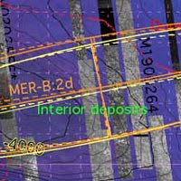
MELAS
The Melas region is a canyon with 10-kilometer
high walls (6 miles high) that "make the Grand Canyon look
insignificant," said Golombek. "There is a area at its very
center that has interior deposits that look like some type of sedimentary
rock. Did these rocks form in water, was there a lake there? Were the
layers deposited by water? Are they due to wind erosion or some other
process? It's a prime place to address very important questions."
Attractive though it is, said Golombek, Melas is surrounded by sand
dunes. A bullseye in targeting would put the lander in fascinating terrain,
but anything short of that could be disappointing.
GUSEV CRATER
"Gusev is perhaps the classic crater that looks like it was a
crater lake," said Golombek.. "For all the world, it looks like a
crater that filled with water, which at some point breached the crater wall
and the water escaped. If this occurred, the crater should be filled with
sediments deposited in the lake." And if the sediments are there,
they were laid down in watery solutions that will provide valuable clues in
the search for water's past on Mars.
The original landing ellipse considered for Gusev was found to contain
some rough-looking terrain in Mars Global Surveyor data, so the ellipse
was moved to gentler terrain slightly to the west.
ATHABASCA VALLES
Finally, there's Athabasca Valles in the Elysium Planitia,
or the "Plains of Elysium." "It is one of the youngest
outflow channels on Mars," said Golombek. "It's hundreds of
kilometers long with a catastrophic outflow channel, kind of like Ares
Valles where Pathfinder landed. Geologically, it's very young, just tens to
hundreds of millions of years old." The channel has been worn by
water and has young volcanics as well, making it a prime location to look
for hydrothermal deposits.
Runners-Up
 |
|
Isidis Planitia |
 |
|
Eos Chasma |
Two backup sites wait in the wings in case there are problems found
with the other sites: Isidis Planitia [image link] and Eos Chasma [image link].
The former sits close to some of the oldest material exposed on Mars, near
the rim of a giant impact basin. The area is expected to be rich in very old
rocks and so may provide clues to the early environment and whether it
was watery or not.
Telecommunications Constraints
Telecommunications constraints will bear on the selection of the final
two sites. The two rovers will communicate via the same
Deep Space Network
and Mars orbiter spacecraft antennas, so the rovers must be
separated by at least 36 degrees in latitude so there will be no
telecommunications overlap between the two. If Hematite is chosen as
one of the sites, it is located far enough away from the other sites that
there would be no overlap, said Golombek.
Choosing the Right Targets
In April 2002, the third landing site workshop will meet in Pasadena to
share any new scientific information gained about the top sites, and to
discuss and evaluate the safety of the sites with mission engineers.
From the discussions, two sites will be selected for landing the two Mars
Exploration Rover spacecraft.
A Little Help from Orbiter Friends
"This is a unique period where we have orbital missions that can
help us make the selection," he said. Mars Global Surveyor's
continuing presence at Mars, now coupled with Mars Odyssey, provides
unprecedented tools to gather targeted information down to 3-meter
resolution - about the length of a small sedan -- to help scientists make
the landing site selection.
Golombek compares today's comparative wealth of detailed data with
the relative paucity of information he had in selecting Pathfinder's landing
site in the mid-1990s. Studying images from the 1970s-era Viking
mission, "we had a hundred meter resolution for the Pathfinder
landing site. That's about the size of a football field. Now, we're
directing the Mars orbiter camera on Surveyor to get pictures of landing
sites at 3-meters resolution. Our data sets for Mars are so new and
growing so quickly. It's a very dynamic, exciting time for Mars
exploration."
Suitable for Human Landing?
Though no human exploration missions are planned for Mars yet,
Golombek says the landing site selections could be driven by different
constraints. "For future astronauts, water would be a prime
resource," he said, noting that the hydrogen and oxygen in water
could be a source for rocket fuel for a return trip to Earth. "There
could be a completely different suite of constraints that could take you to
completely different sites than we're considering right now," he said.
|