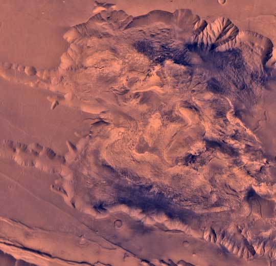
| West Candor Chasma
During its examination of Mars, the Viking 1 spacecraft returned
images of Valles Marineris, a huge canyon system 5,000 km long, up
to 240 km wide, and 6.5 km deep, whose connected chasma or valleys
may have formed from a combination of erosional collapse and
structural activity. The view shows west Candor Chasma, one of the
connected valleys of Valles Marineris; north toward top of frame.
The image is a composite of Viking high-resolution (about 80 m/pixel
or picture element) images in black and white and low resolution
(about 250 m/pixel) images in color. The Viking 1 craft landed on
Mars in July of 1976. West Candor Chasma occupies the westernmost
part of the large west- northwest-trending trough of Candor
Chasma. This section is about 150 km wide. West Candor Chasma is
bordered on the north and south by straight- walled cliffs, most likely
faults, and on its west by two segments of north-northeast-trending cliffs.
The north wall is dissected by landslide scars forming reentrants
filled with landslide debris. The south wall shows spur-and-gully
morphology and smooth sections. The high-standing central mesa,
informally dubbed Red Mesa has several curvilinear reentrants
carved into the caprock, whose anomalously colored layers were
interpreted to be caused by young hydrothermal alteration products
(Geissler et al., 1993, Icarus, v. 106, p. 380-391). Light-colored lobes
flow away from the top of the interior stack and then flow around
and embay the same layered stack from which they originated.
One of these apparent flow features is composed of at least two or
perhaps even three huge, superposed, vaguely layered, very rugged,
light-colored lobes as much as 100 km long, 20 km wide, and over
2 km thick. The layered deposits below the caprock also merge with
a chaotic material that has local lobate fronts and overlaps landslide
deposits. Hummocky material, similar in hue to wall rock, fills the
southwesternmost region of west Candor Chasma and is perhaps
as much as 3 km thick (Lucchitta, 1990, Icarus, v. 86, p. 476- 509).
The light-colored lobes, chaotic material, and hummocky fill may be
mass wasting deposits due to wholesale collapse of older interior
deposits (Lucchitta, 1996, LPSC XXVII abs., p. 779- 780); this
controversial idea requires that the older layered deposits were
saturated with ice, perhaps from former lakes and that young
volcanism and/or tectonism melted the ice and made the material flow.
|