| First THEMIS Image of Mars
This thermal infrared image was acquired by Mars Odyssey's thermal emission imaging system on October 30, 2001, as the spacecraft orbited Mars on its ninth revolution around the planet. The image was taken as part of the calibration and testing process of the camera system.
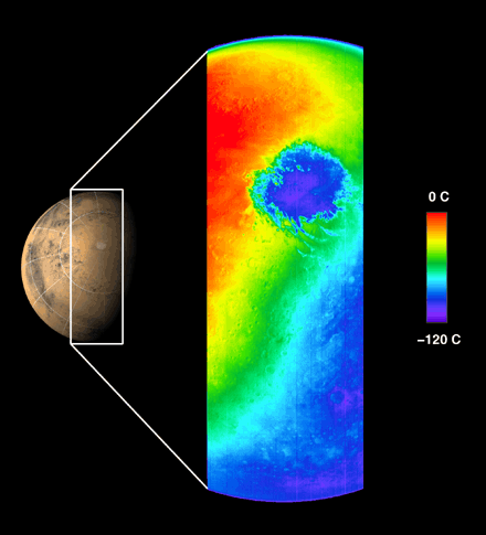
This image shows the temperature of Mars in one of the 10 thermal infrared filters. The spacecraft was approximately 22,000 kilometers (about 13,600 miles) above the planet looking down toward the south pole of Mars when this image was acquired.
It is late spring in the martian southern hemisphere. The extremely cold, circular feature shown in blue is the martian south polar carbon dioxide ice cap at a temperature of about -120 °C (-184 ° F). The cap is more than 900 kilometers (540 miles) in diameter at this time and will continue to shrink as summer progresses. Clouds of cooler air blowing off the cap can be seen in orange extending across the image to the left of the cap. The cold region in the lower right portion of the image shows the nighttime temperatures of Mars, demonstrating the "night-vision" capability of the camera system to observe Mars even when the surface is in darkness. The warmest regions occur near local noontime. The ring of mountains surrounding the 900-kilometer (540-mile) diameter impact basin Argyre can be seen in the early afternoon in the upper portion of the image. The thin blue crescent along the upper limb of the planet is the martian atmosphere.
This image covers a length of over 6,500 kilometers (3,900 miles) spanning the planet from limb to limb, with a resolution of approximately 5.5 kilometers per pixel (3.4 miles per pixel), or picture elements, at the point directly beneath the spacecraft. The Odyssey's infrared camera is planned to have a resolution of 100 meters per pixel (about 300 feet per pixel) from its mapping orbit.
JPL manages the 2001 Mars Odyssey mission for NASA's Office of Space Science, Washington, D.C. The thermal emission imaging system was developed at Arizona State University, Tempe with Raytheon Santa Barbara Remote Sensing, Santa Barbara, Calif. Lockheed Martin Astronautics, Denver, Colo., is the prime contractor for the project, and developed and built the orbiter. Mission operations are conducted jointly from Lockheed Martin and from JPL, a division of the California Institute of Technology in Pasadena.
Image credit: NASA/Jet Propulsion Laboratory/Arizona State University.
|