| North Polar Cap in Summer
In the middle of January 2001, Mars Global Surveyor (MGS) completed
one Mars year in its ~380 km-high (236 mi) mapping orbit. The mapping
orbit was originally achieved in late February 1999. In March of that
year, MGS conducted a series of operations in preparation for full-up
mapping, first calibrating its scientific instruments and then operating
in a mode in which the high gain antenna was held fixed against the
body of the spacecraft. During this Fixed High Gain Antenna period,
'contingency science' observations were made in case the high gain
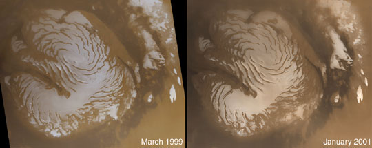
antenna failed to properly deploy. The wide angle view of the martian
north polar cap shown on the left was acquired on March 13, 1999,
during early northern summer. The image on the right was acquired
almost exactly one Mars year later, on January 26, 2001. The
light-toned surfaces are residual water ice that remains through the
summer season. The nearly circular band of dark material surrounding
the cap consists mainly of sand dunes formed and shaped by wind.
The north polar cap is roughly 1100 kilometers (680 miles) across.
Close inspection will show that there are differences in the frost cover
between the two images (for example, in the upper center of each
image, and on the left edge center). Although these changes appear
small, they are in fact quite large--the change in frost covering is
equivalent to the amount of frost that would be evaporated (in the
case of areas that are darker) or deposited (in areas where frost is
still on the ground) in almost 5 months. What gives rise to such large
changes in the heat budget for the polar caps from one year to the
next is not known. Changes in the coloration and brightness of the
polar cap suggest dust, deposited perhaps by dust storms during
critical periods of the year, may play an important role.
Photo Credit: NASA/JPL/Malin Space Science Systems
|