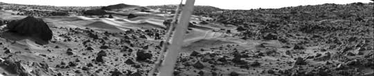
| Martian Dune Field
This spectacular picture of the Martian landscape by the Viking 1
Lander shows a dune field with features remarkably similar to many seen
in the deserts of Earth. The dramatic early morning lighting- - 7:30 a.m.
local Mars time--reveals subtle details and shading. Taken yesterday
(August 3) by the Lander s camera #1, the picture covers 100° , looking
northeast at left and southeast at right. Viking scientists have studied
areas very much like the one in this view in Mexico and in California
(Kelso, Death Valley, Yuma). The sharp dune crests indicate the most
recent wind storms capable of moving sand over the dunes in the
general direction from upper left to lower right. Small deposits
downwind of rocks also indicate this wind direction. Large boulder at
left is about eight meters (25 feet) from the spacecraft and measures
about one by three meters (3 by 10 feet). The meteorology boom,
which supports Viking's miniature weather station, cuts through the
picture's center. The sun rose two hours earlier and is about 30° above
the horizon near the center of the picture.
|